DJI MATRICE 300 RTK Drone Pack

This product is discontinued.
This is the model that replaces it:

Description

DJI MATRICE 300 RTK Drone Pack

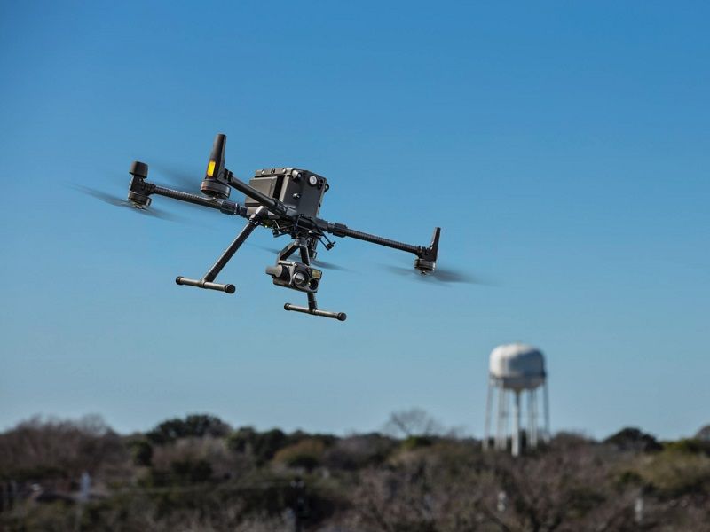
The Matrice 300 RTK drone is DJI's newest commercial platform, and is inspired by state-of-the-art avionics systems. It offers a flight time of up to 55 minutes, advanced AI and a UAV status management system, among others. The M300 RTK redefines what you can expect from a business drone with a leading combination of intelligent features, high performance and reliability. Compatible with, among others, FLIR Zenmuse XT2 and FLIR TZ20-R thermal imaging cameras.

Improved transmission system

The new OcuSync Enterprise offers a transmission distance of up to 15 km and is capable of transmitting 1080p video signal over three channels3. Automatic real-time switching between the 2.4 GHz and 5.8 GHz frequency bands4 enables more stable flight near high interference environments, while AES-256 encryption provides secure data transmission.

  • Transmission range - 15 Km
  • Triple channel video - 1080p
  • Real-time automatic switching -2.4 and 5.8 GHz

Improved flight performance

The improved design of the propulsion system and aerostructure provides more efficient and stable flight even in difficult conditions.

  • Max. flight time - 55 min
  • Max. descent speed - 7m/s
  • Max. flight altitude - 7000m
  • Max. wind resistance - 12m/s
  • Max. speed - 23m/s

Various loading configurations

Configure the M300 RTK drone to suit your needs. Mount up to three payloads simultaneously, with a maximum payload capacity of 2.7 kg.

  • Unique stabilizer at the bottom
  • Single upper stabilizer - Single lower stabilizer
  • Single upper stabilizer - Double lower stabilizer

Intelligent inspections

Live Mission Recording

It records mission actions such as aircraft movement, stabilizer orientation, photo capture functions and zoom level to create example mission files and automate future inspections.

Artificial intelligence targeting (AI Spot-Check)

Automates routine inspections and captures consistent results every time. Onboard artificial intelligence recognizes the target of interest and identifies it in subsequent automated missions to ensure consistent framing.

Waypoints 2.0 (Waypoints 2.0)

Create up to 65,535 waypoints and schedule multiple actions for one or more payloads, including third-party payloads, at each of these points. Flight path planning has also been optimized to maximize the flexibility and efficiency of your missions.

Smart Pin & Track (Smart Pin & Track)

Pin Point
Pin point an object in the camera or map view with just one touch. Advanced data fusion algorithms will automatically obtain its coordinates and project them on all camera views as an AR icon. The target location will be automatically shared with another remote control or online platforms, such as DJI FlightHub9.

Smart Track
Identifies and tracks moving targets such as people, vehicles or boats with the Smart Track feature. Automatic zoom is applied for stable tracking and viewing. Dynamic target location is continuously obtained and shared with another remote control or DJI FlightHub9.

All the information you need

The M300 RTK features a Flight Main Display (PFD), which integrates flight, navigation and obstacle information to give the pilot an exceptional awareness of the environment.

Flight information
Flight information, such as aircraft position, altitude and speed, as well as wind speed and direction, are presented intuitively.

Navigation display
Pilots will also be able to see more efficiently and in real time the aircraft trajectory, target location and origin point projection. View all nearby obstacles with the new obstacle map to keep you informed.

Advanced dual control

Either operator will be able to control the aircraft or cargo with just one touch. This provides new possibilities for mission strategies, as well as greater flexibility during operations.

Safe and reliable

Controls a powerful vision system
To enhance the safety and stability of the aircraft during flight, the aircraft features dual vision and infrared sensors on all six sides. This enhancement offers a greater detection range of up to 40 m, with options to customize the behavior of the aircraft's sensors through the DJI Pilot app. Even in complex operating environments, this six-way sensing and positioning system protects both the aircraft and the mission.

Professional maintenance for your drone fleet

The new integrated status management system displays the current status of all systems, notification logs and a preliminary troubleshooting guide. The system also includes flight logs, the duration and distance flown of the aircraft throughout its life cycle, and tips for caring for and maintaining the aircraft.


Ref.M300-RTK

DJI MATRICE 300 RTK Drone - Presentation

DJI MATRICE 300 RTK Drone - Power Line Inspection

DJI MATRICE 300 RTK Drone - Increasing inspection efficiency

DJI MATRICE 300 RTK Drone - First Flight Tutorial

Technical data

  • Dimensions

Unfolded, propellers and landing gear included: 810 × 670 × 430 mm (length × width × height)
Folded, including propellers and landing gear: 430 × 420 × 430 mm (L × W × H)

  • Diagonal distance between axles

895 mm

  • Weight (with only a single lower stabilizer)

Approx 3.6 kg (with batteries)
Approx. 6.3 kg (with two TB60 batteries)

  • Max. load

2.7 kg

  • Max. take-off weight

9 kg

  • Operating frequency

2.4000-2.4835 GHz
5.725-5.850 GHz

  • PIRE

2.4000-2.4835 GHz:
29.5 dBm (FCC); 18.5 dBm (CE).
18.5 dBm (SRRC); 18.5 dBm (MIC)

5.725-5.850 GHz:
28.5 dBm (FCC); 12.5 dBm (CE).
28.5 dBm (SRRC)

  • Accuracy in hovering flight (P mode, with GPS)

Vertical:
±0.1 m (vision system on).
±0.5 m (GPS enabled)
±0.1 m (RTK activated)

Horizontal:
±0.3 m (vision system on).
±1.5 m (GPS activated)
±0.1 m (RTK activated)

  • RTK positioning accuracy

With RTK activated and fixed:
1 cm + 1 ppm (Horizontal).
1.5 cm + 1 ppm (Vertical)

  • Max. angular velocity

Tilt: 300°/s, Turn: 100°/s

  • Maximum angle of inclination

30° (mode P, front view system activated: 25°)

  • Max. ascent speed

Mode S: 6 m/s
Mode P: 5 m/s

  • Max. descent speed (vertical)

Mode S: 5 m/s
Mode P: 4 m/s

  • Max. descent speed (inclination)

Mode S: 7 m/s

  • Max. speed

Mode S: 23 m/s
Mode P: 17 m/s

  • Max. flight altitude

5000 m (with 2110 propellers, takeoff weight ≤7 kg) / 7000 m (with 2195 propellers, takeoff weight ≤7 kg).

  • Max. wind resistance

Max. wind resistance 15 m/s (12 m/s on take-off or landing)

  • Max. flight time

55 min

  • Compatible FLIR/DJI stabilizers

Zenmuse XT2/XT S/Z30/H20/H20T/DJI P1/DJI L1

  • Possible stabilizer configurations

Single lower stabilizer, two lower stabilizers, single upper stabilizer, upper and lower stabilizers, three stabilizers

  • Protection index

IP45

  • GNSS

GPS+GLONASS+BeiDou+Galileo

  • Operating temperature

From -20 to 50 °C (-4 to 122 °F)

Remote control

  • Operating frequency

2.4000-2.4835 GHz
5.725-5.850 GHz

  • Max. transmission distance (unobstructed, free from interference)

NCC/FCC: 15 km
CE/MIC: 8 km
SRRC: 8 km

  • PIRE

2.4000-2.4835 GHz:
29.5 dBm (FCC); 18.5 dBm (CE).
18.5 dBm (SRRC); 18.5 dBm (MIC)

5.725-5.850 GHz:
28.5 dBm (FCC); 12.5 dBm (CE).
20.5 dBm (SRRC)

  • External battery

Name: Smart Battery WB37
Capacity: 4920 mAh
Voltage: 7.6 V
Type: LiPo
Power: 37.39 Wh
Charging time (with BS60 Smart Battery Station): 70 min (15 to 45 °C); 130 min (0 to 15 °C)

  • Integrated battery

Type: 18650 lithium-ion battery (5000 mAh at 7.2 V)
Charging: use a USB charger with 12 V/2 A specification
Power rating: 17 W
Charging time: 2 h and 15 min (uses a USB charger with 12 V/2 A specification)

  • Battery life

Built-in battery: approx. 2.5 h
Built-in battery + external battery: approx. 4.5 h

  • USB power supply

5 V/1.5 A

  • Operating temperature

From -20 to 40 °C (-4 to 104 °F)

Vision system

  • Obstacle detection range

Front/rear/left/right/right: 0.7-40 m
Top/bottom: 0.6-30 m

  • Field of view (FOV)

Front/rear/lower: 65° (H), 50° (V)
Left/right/top: 75° (H), 60° (V)

  • Operating environment

Surfaces with defined patterns and adequate illumination (>15 lux)

Infrared detection system

  • Obstacle detection range

0.1-8 m

  • Field of view (FOV)

30° (±15°)

  • Operating environment

Large, diffuse, reflective obstacles (reflectivity >10%)

Upper and lower auxiliary light

  • Effective illumination distance

5 m

FPV camera

  • Resolution

960p

  • Field of view (FOV)

145°

  • Frame rate

30 fps

Intelligent Flight Battery

  • Name

TB60

  • Capacity

5935 mAh

  • Voltage

52.8 V

  • Battery type

LiPo 12S

  • Energy

274 Wh

  • Net weight

Approx. 1.35 kg

  • Operating temperature

From -20 to 50 °C (-4 to 122 °F)

  • Ideal storage temperature

22 to 30 °C (71.6 to 86 °F)

  • Charging temperature

From -20 to 40 °C (-4 to 104 °F)
(When the temperature is below 5 °C (41 °F), the self-heating function is automatically activated. Charging at low temperatures may reduce battery life).

  • Charging time

With the BS60 Smart Battery Station:
220 V input: 60 minutes (full charge of two TB60 batteries), 30 minutes (charging of two TB60 batteries from 20 to 90 %).
110 V input: 70 minutes (full charge of two TB60 batteries), 40 minutes (charge of two TB60 batteries from 20 to 90 %)

BS60 Smart Battery Station

  • Dimensions

501 × 403 × 252 mm

  • Net weight

8.37 kg

  • Maximum capacity

Intelligent Flight Battery TB60 × 8
WB37 Intelligent Battery × 4

  • Entrance

100-120 VAC, 50-60 Hz/220-240 VAC; 50-60 Hz

  • Max. input power

1070 W

  • Power output

  • 100-120 V: 750 W
    220-240 V: 992 W

  • Operating temperature

  • From -20 to 40 °C (-4 to 104 °F)

Related products