Drone DJI MAVIC 3 THERMAL

Includes:
- Mavic 3T Aircraft
- Mavic 3 Intelligent Flight Battery
- 64GB microSD card
- Stabilizer protector
- 3x Propellers (pair) Mavic 3 Enterprise Series
- RC Control Pro Enterprise
- Screwdriver
- USB-C Power Adapter (100W)
- 100W AC power adapter cable
- USB-C cable
- USB-C to USB-C cable
- Protective case

This product is discontinued.
This is the model that replaces it:
DJI-Matrice-4T

DJI Matrice 4T Drone Pack

5.701,65+ VAT

Description

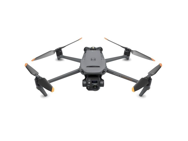
DJI MAVIC 3 THERMAL Drone with Thermal Imaging Camera

The DJI MAVIC 3 Thermal drone with thermal camera redefines industry standards for small commercial drones. With a mechanical shutter, 56× zoom camera and RTK module for centimeter accuracy, the Mavic 3 T takes mapping and mission efficiency to new heights. A thermal version is available for firefighting missions, search and rescue, inspections and night operations.

  • Compact and portable
  • Wide-angle camera with 4/3 CMOS
  • 56× hybrid zoom
  • Thermal camera 640×512 px, DFOV: 61°, equivalent focal length: 40 mm, resolution: 640×512
  • 45 min max. flight time
  • DJI O3 Enterprise Transmission
  • Centimeter-accurate positioning with RTK
  • High volume loudspeaker
  • Wide angle
  • Equivalent focal length: 24 mm, 48 MP
  • Telecamera
  • Equivalent focal length: 162 mm, 12 MP, 56× hybrid zoom

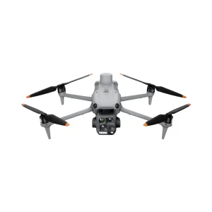
DJI MAVIC 3 Compact and Portable Drone

Aerodynamic and compact, the Mavic 3 Enterprise Series can be carried in one hand and deployed on the fly. Perfect for both novice and expert pilots, it is designed for extended missions.

Focus and find with MAVIC 3

Equipped with a 12 MP zoom camera, which supports hybrid zoom up to 56×, for viewing essential details from afar.

See the never-before-seen with the DJI MAVIC 3 thermal camera

The Mavic 3T 's thermal camera has a 640×512 resolution and enables spot and area temperature measurement, high temperature alerts, color palettes and isotherms to help you find your targets and make quick decisions.

Simultaneous zoom in split screen 

The Mavic 3T 's thermal imager and zoom camera allow 28× continuous side-by-side zoom for easy comparison.

Batteries optimized to last

45 minutes of flight time allows you to cover more ground on each mission, mapping up to 2 km2 in a single flight.

Measurement area in a single flight

2 square kilometers

State-of-the-art image transmission

The O3 Enterprise transmission with cubic antenna enables more stable connections in a variety of complex environments.

Omnidirectional sensing for safe flight

Equipped with wide-angle lenses on all sides for an omnidirectional anti-collision system with no blind spots. Adjusts proximity alarms and braking distance according to the mission requirements.[6][7

The advanced RPO automatically plans the optimal return route to save energy, time and worry.

Ref.MAVIC 3T

DJI MAVIC 3 Enterprise Drone | Everything You Need To Know

DJI MAVIC 3 Thermal Drone - Presentation

DJI MAVIC 3 Enterprise Drone | Your Everyday Commercial Drone

Technical data

Aircraft

  • Weight (with propellers, without accessories)[1] Weight (with propellers, without accessories)[1] Weight (with propellers, without accessories)[1

  • 920 g

  • Max. take-off weight

  • 1050 g

  • Dimensions

  • Folded (without propellers): 221 × 96.3 × 90.3 mm (L × W × H)
    Unfolded (without propellers): 347.5 × 283 × 107.7 mm (L × W × H)

  • Diagonal distance

  • 380.1 mm

  • Max. ascent speed

  • 6 m/s (Normal mode)
    8 m/s (Sport mode)

  • Max. descent speed

  • 6 m/s (Normal mode)
    6 m/s (Sport mode)

  • Max. flight speed (at sea level, without wind)

  • 15 m/s (Normal mode)
    Forward: 21 m/s; sideways: 20 m/s; backward: 19 m/s (Sport mode)[2].

  • Max. wind resistance

  • 12 m/s[3]

  • Max. takeoff altitude above sea level

  • 6000 m (without load)

  • Max. flight time (no wind)

  • 45 min[4]

  • Max. stationary flight time (no wind)

  • 38 min

  • Max. flight distance

  • 32 km

  • Max. angle of inclination

  • 30° (Normal mode)
    35° (Sport mode)

  • Max. angular velocity

  • 200°/s

  • GNSS

  • GPS + Galileo + BeiDou + GLONASS (GLONASS is only supported when the RTK module is activated)

  • Accuracy in hovering flight

  • Vertical: ±0.1 m (vision system activated); ±0.5 m (with GNSS); ±0.1 m (RTK)
    Horizontal: ±0.3 m (with vision system); ±0.5 m (with high-precision positioning system); ±0.1 m (with RTK)

  • Operating temperature range

  • From -10 to 40 °C (14 to 104 °F)

  • Internal memory

  • N/A

  • Engine model

  • 2008

  • Propeller model

  • 9453F propellers for Enterprise

  • Beacon

  • Integrated in the aircraft

Wide-angle camera

  • Sensor

  • 1/2-inch CMOS; effective pixels: 48 MP

  • Target

  • FOV: 84°.
    Equivalent format: 24 mm
    Aperture: f/2.8
    Focus: 1 m up to ∞

  • ISO range

  • 100-25 600

  • Shutter speed

  • Electronic shutter: 8-1/8000 s

  • Max. image size

  • 8000×6000

  • Still photography modes

  • Single shot: 12 MP/48 MP
    Self-timer: 12 MP/48 MP
    JPEG: 2/3/5/7/10/15/20/30/60s*.
    * 48 MP photo capture does not support 2 s interval.
    Intelligent low light capture: 12 MP
    Panorama: 12 MP (raw image); 100 MP (combined image)

  • Video resolution

  • H.264
    4K: 3840×2160 at 30 fps
    FHD: 1920×1080 at 30 fps

  • Bit rate

  • 4K: 85 Mb/s
    FHD: 30 Mb/s

  • Supported file formats

  • exFAT

  • Photo format

  • JPEG

  • Video format

  • MP4 (MPEG-4 AVC/H.264)

Telecamera

  • Sensor

  • 1/2 inch CMOS; effective pixels: 12 MP

  • Target

  • FOV: 15°.
    Format equivalent: 162 mm
    Aperture: f/4.4
    Focus: 3 m up to ∞

  • ISO range

  • 100-25 600

  • Shutter speed

  • Electronic shutter: 8-1/8000 s

  • Max. image size

  • 4000×3000

  • Photo format

  • JPEG

  • Video format

  • MP4 (MPEG-4 AVC/H.264)

  • Still photography modes

  • Single shot: 12 MP
    Self-timer: 12 MP
    JPEG: 2/3/5/7/10/15/20/30/60 s
    Intelligent low light shooting: 12 MP

  • Video resolution

  • H.264
    4K: 3840×2160 at 30 fps
    FHD: 1920×1080 at 30 fps

  • Bit rate

  • 4K: 85 Mb/s
    FHD: 30 Mb/s

  • Digital zoom

  • 8x (56x hybrid zoom)

Thermal camera[5]

  • Thermograph

  • Uncooled VOx microbolometer

  • Pixel pitch

  • 12 μm

  • Frame rate

  • 30 Hz

  • Target

  • DFOV: 61
    Equivalent format: 40 mm
    Aperture: f/1.0
    Focus: 5 m up to ∞

  • Sensitivity

  • ≤50 mK at F1.1

  • Temperature measurement method

  • Spot meter, area measurement

  • Temperature measuring range

  • 20 to 150 °C (-4 to 302 °F, high gain mode)
    0 to 500 °C (32 to 932 °F, low gain mode)

  • Palette

  • Hot White/Hot Black/Hot Black/Dye/Iron Red/Hot Iron/Hot Iron/Arctic/Medical/Fulgurite/Rainbow 1/Rainbow 2

  • Photo format

  • JPEG (8-bit)
    R-JPEG (16 bits)

  • Video resolution

  • 640×512 at 30 fps

  • Bit rate

  • 6 Mb/s

  • Video format

  • MP4 (MPEG-4 AVC/H.264)

  • Still photography modes

  • Single shot: 640×512
    With timer: 640×512
    JPEG: 2/3/5/7/10/15/20/30/60 sec.

  • Digital zoom

  • 28x

  • Infrared wavelength

  • 8-14 μm

  • Infrared temperature measurement accuracy

  • ±2 °C or ±2 % (using the higher value)

Stabilizer

  • Stabilization

  • 3 axes (tilt, rotation, pan)

  • Mechanical range

  • DJI Mavic 3T:
    Tilt: from -135° to 45°.
    Rotation: from -45° to 45°.
    Pan: -27° to 27° Pan: -27° to 27° Pan: -27° to 27

  • Controllable range

  • Tilt: from -90° to 35°.
    Rotation: not controllable

  • Max. control speed (inclination)

  • 100°/s

  • Angular vibration range

  • ±0.007°

Detection

  • Type

  • Omnidirectional binocular vision system, supplemented with an infrared sensor on the bottom of the aircraft.

  • Front

  • Measuring range: 0.5-20 m
    Detection range: 0.5-200 m
    Effective detection speed: flight speed ≤15 m/s
    Field of view: horizontal: 90°; vertical: 103°.

  • Rear

  • Measurement range: 0.5-16 m
    Effective detection speed: flight speed ≤12 m/s
    Field of view: horizontal: 90°; vertical: 103°.

  • Lateral

  • Measurement range: 0.5-25 m
    Effective detection speed: flying speed ≤15 m/s
    Field of view: horizontal: 90°; vertical: 85°.

  • Superior

  • Measurement range: 0.2-10 m
    Effective detection speed: flight speed ≤6 m/s
    Field of view: front and rear: 100°; left and right: 90°.

  • Inferior

  • Measurement range: 0.3-18 m
    Effective detection speed: airspeed ≤6 m/s
    Field of view: front and rear: 130°; left and right: 160°.

  • Operating environment

  • Front, rear, side and top: surface with a defined pattern and adequate illumination (lux >15)
    Lower: surface with diffuse reflectivity >20% (e.g. walls, trees, people) and adequate illumination (lux >15)

Video transmission

  • Video transmission system

  • DJI O3 Enterprise Transmission

  • Quality of the live view

  • Remote control: 1080p/30 fps

  • Operating frequency[6]

  • 2.400-2.4835 GHz
    5.725-5.850 GHz

  • Max. transmission distance (unobstructed, interference-free)[7] Max. transmission distance (unobstructed, interference-free)[7] Max. transmission distance (unobstructed, interference-free)[7

  • FCC: 15 km
    EC: 8 km
    SRRC: 8 km
    MIC: 8 km

  • Max. transmission distance (without obstacles)[8]

  • Strong interference (urban centers, residential areas, etc.): 1.5-3 km (FCC/CE/SRRC/MIC)
    Medium interference (suburban areas, urban parks, etc.): 3-9 km (FCC), 3-6 km (EC/SRRC/MIC)
    Weak interference (open spaces, remote areas, etc.): 9-15 km (FCC), 6-8 km (EC/SRRC/MIC)

  • Max. download speed [9]

  • 15 MB/s (with DJI RC Pro Enterprise)

  • Latency (depends on environmental conditions and mobile device)

  • Approx. 200 ms

  • Antenna

  • 4 antennas, 2T4R

  • Transmission power (EIRP)

  • 2.4 GHz: <33 dBm (FCC), <20 dBm (CE/SRRC/MIC)
    5.8 GHz: <33 dBm (FCC), <30 dBm (SRRC), <14 dBm (CE)

DJI RC Pro Enterprise

  • Video transmission system

  • DJI O3 Enterprise Transmission

  • Max. transmission distance (unobstructed, interference-free)[7] Max. transmission distance (unobstructed, interference-free)[7] Max. transmission distance (unobstructed, interference-free)[7

  • FCC: 15 km
    CE/SRRC/MIC: 8 km

  • Operating frequency of video transmission[6]

  • 2.400-2.4835 GHz
    5.725-5.850 GHz

  • Antenna

  • 4 antennas, 2T4R

  • Power of video transmission transmitter (PIRE)

  • 2.4 GHz: <33 dBm (FCC), <20 dBm (CE/SRRC/MIC)
    5.8 GHz: <33 dBm (FCC), <14 dBm (CE), <23 dBm (SRRC)

  • Wi-Fi protocol

  • 802.11 a/b/g/n/ac/ax
    Supports Wi-Fi MIMO 2×2

  • Operating frequency[6]

  • 2.400-2.4835 GHz
    5.150-5.250 GHz
    5.725-5.850 GHz

  • Power of Wi-Fi transmitter (PIRE)

  • 2.4 GHz: <26 dBm (FCC), <20 dBm (CE/SRRC/MIC)
    5.1 GHz: <26 dBm (FCC), <23 dBm (CE/SRRC/MIC)
    5.8 GHz: <26 dBm (FCC/SRRC), <14 dBm (CE)

  • Bluetooth protocol

  • Bluetooth 5.1

  • Bluetooth operating frequency

  • 2.400-2.4835 GHz

  • Bluetooth transmitter power (PIRE)

  • <10 dBm

  • Screen resolution

  • 1920×1080

  • Screen size

  • 5.5 inches

  • Screen frame rate

  • 60 fps

  • Display brightness

  • 1000 nits

  • Touch screen control

  • 10-point multi-touch

  • Battery

  • Li-ion (5000 mAh at 7.2 V)

  • Type of load

  • Charging with the included DJI USB-C (100 W) USB-C power adapter or a 12V or 15V USB charger is recommended.

  • Power rating

  • 12 W

  • Storage capacity

  • Internal memory (ROM): 64 GB
    Supports microSD card to increase capacity

  • Charging time

  • Approx. 1 hour and 30 minutes (with DJI USB-C (100 W) power adapter charging remote control only or 15V USB charger)
    Approx. 2 hours (with 12V USB charger)
    Approx. 2 hours and 50 minutes (with DJI USB-C (100 W) power adapter charging the aircraft and remote control simultaneously)

  • Operating time

  • Approx. 3 hours

  • Video output port

  • Mini-HDMI port

  • Operating temperature range

  • From -10 to 40 °C (14 to 104 °F)

  • Storage temperature

  • 30 to 60 °C (-22 to 140 °F) (less than one month)
    30 to 45 °C (-22 to 113 °F) (one to three months)
    30 to 35 °C (-22 to 95 °F) (three to six months)
    30 to 25 °C (-22 to 77 °F) (more than six months)

  • Charging temperature

  • 5 to 40 °C (41 to 104 °F)

  • Compatible DJI aircraft[10]

  • DJI Mavic 3E
    DJI Mavic 3T

  • GNSS

  • GPS + Galileo + GLONASS

  • Dimensions

  • Antennas folded and control levers unmounted:
    183.27 × 137.41 × 47.6 mm (l. × w. × h.)
    Antennas unfolded and control levers mounted:
    183.27 × 203.35 × 59.84 mm (la. × w. × h.)

  • Weight

  • Approx. 680 g

  • Model

  • RM510B

Storage

  • Compatible memory cards

  • Aircraft:
    U3/Class10/V30 or higher is required. Below is a list of recommended microSD cards.

Related products